Day 49: Fell
- dave7057
- Jul 2, 2017
- 7 min read
Updated: Feb 11, 2021
Dufton to Alston. 20.6 miles. 721.4 miles to date.
Cross Fell is not only the highest point in the Pennines at 2,930ft, and the highest point in England outside of the Lake District, it’s also likely to be the highest point on my LeJog trip, assuming I don’t develop delusions of Munro grandeur after one too many whiskies as I head through Scotland.
But the way I'm feeling right now I’d happily shove on some headphones and limp canals for the remaining five-hunded-and-something miles while listening to Mike Harding Folk Show podcasts.

I love the reputation that surrounds Cross Fell among Pennine Way walkers and the guidebooks they follow.
Cross Fell is, the books note in ominous tones, higher than the Lake District giant of Pillar, its crossing long and gruelling. With no accommodation between the start point of Dufton and the destination of Alston bar a remote mountain bothy and a B&B in Garrigill, it's one of the few stages that can't be broken into smaller chunks. Once you're on the tops you either continue, or you accept defeat and backtrack.
It's not just guidebook writers who get spooked by the Pennine giant. Back in the day the hill was known as Fiend's Fell, partly due to its inhospitable flanks, which are invariably lost in heavy cloud (the Helm Bar), but also because when the north-easterly Helm Wind blows the mountain sounds like it's shrieking. Which is, frankly, awesome.
If only the reality of walking the hill was as interesting as the myth.
The truth is comparing Cross Fell with Pillar is to promote it into the company of greats where it doesn't belong. In fact it's just one foot higher than mighty Pillar, and Pillar, with its two tiers of cragged walls, broad summit dominating the Mosedale Horseshoe and awe-inspiring monolith of Pillar Rock is one of the finest heights in England.
Cross Fell is, at best, a bloated moor that, by way of meagre compensation, happens to have a very beautiful set of stone accoutrements on its boring summit.

The superbly built and very beautiful cross-shaped shelter on the top of Cross Fell. The only reason to climb its weary slopes.
The walk began with a pleasant enough ascent to the intake wall through meadows and along an ash-lined green lane. Then it was onto the barren heights for an up-and-down of Knock Fell, Great Dun Fell and Little Dun Fell before reaching the cloud-whipped summit of Cross Fell.
As I gained height, the temperatures dropped and the wind rose (no shrieking, unfortunately) so that by the time I climbed Little Dun Fell I'd transformed from a shorts and T-shirt July rambler to fully wind- and waterproofed winter trailer who was having a tough time holding a straight course as the wind buffeted the heights.
This approach to Cross Fell is a great walk if you like grass, sheep and stones. In addition, some of the summit cairns are things of beauty, and for those with an interest in post-modernist architecture there's the incongruous golfball radar station operated by NATS on Great Dun Fell that plays a key role in air traffic control for the north of England. There's also the scarred remains of a remarkable hushing gully, in which streams were once held back then released to scour the valleyside's topsoil in the hope of revealing minerals below.
But they are scant and ugly features on this long, featureless slog.
Probably the best aspect of climbing Cross Fell is the view west to the Lakeland fells. And while visibility was – when the cloud lifted – pretty good, seeing the shapely peaks of home just made me wish I was there rather on the weary Pennine treadmill.

The village green, Dufton. In the foreground is one of four quaker-gifted water pumps.

Rock musicians.


Lovely green lane.

Packhorse bridge.

The long, featureless track onto Knock Fell. Knock knock. What's there? Nothing.

Grass. There was an awful lot of it, and not much else.

They were repairing some of the paths. The limestone slabs they use are huge.

Shapely Knock Pike. Looked like a more interesting (and shorter) climb than Cross Fell.

Great Rundale Beck. Obviously receives high spate flow.

Cloudy and grim.


The worst of the bogs were flagged.

Dunfell Hush.
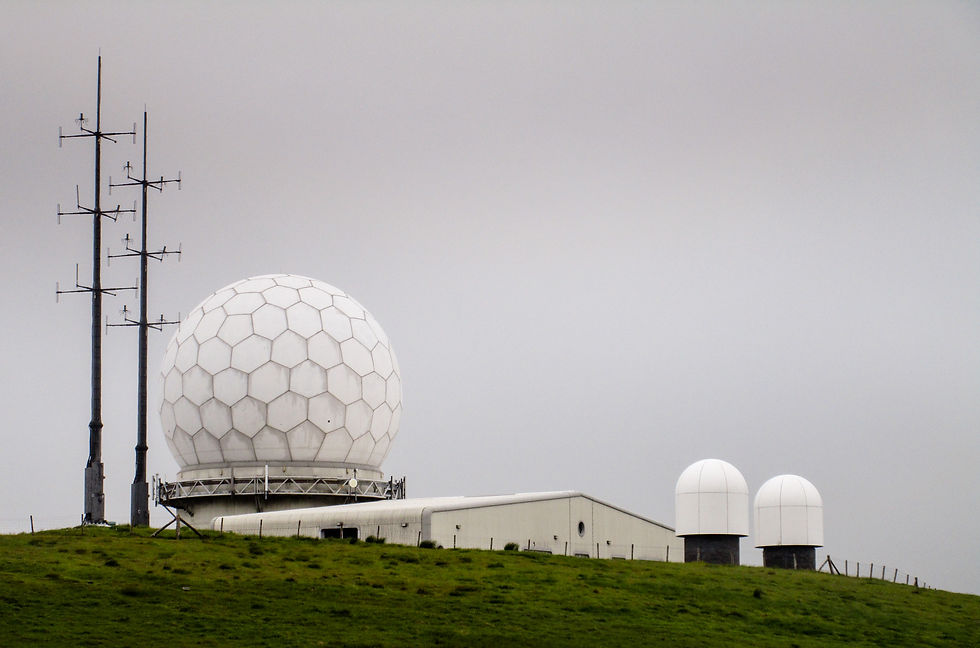
The various white things and antennae on Great Dun Fell that help planes not crash into each other. Given their assumed strategic importance I was surprised at how lax the security was. A couple of walkers had crossed the fence and were having lunch in the shelter of the ball. Maybe would-be terrorists simply can't be bothered to climb up here. Fair enough, I guess.

Little Dun Fell (you can just about make out the path snaking up its shoulder), with Cross Fell in the background.

Fine cairn on the approach to Cross Fell. Whoever's been building the summit rock features around here deserves credit.

Mist.

Silhouettes in the mist on the summit of Cross Fell.
At the top of Cross Fell I meet a Pennine Wayer who's looking for a navigational second opinion in the mist.
I point him in the right direction and we walk together for a while.
His name is Cliff, and he is a Brit now living in the US.
He is back to catch up with old friends and have the mother of all walks.
"I sat down," he tells me, "and made a list of everything I love. Hills. Peace and quiet. Big spaces. English pubs. Villages. I thought how can I get all of these in a single walk, and the answer was the Pennine Way."

A bundle of laughs on the summit of Cross Fell.
I’d been ready to write off the walk and damn the day when the summit cloud lifted and the onward journey revealed itself: a crossing of the upland wilderness of Alston Moor that I’d been eyeing warily from the Dun Fells earlier, thinking that – surely – the Way couldn't cross that.
It's impossible to do justice to the scale of emptiness that characterises so much of the north Pennines. From the windswept summit of Great Dun Fell you look east and see nothing but moors, receding to the horizon by way of a hundred ever-mistier slopes. No roads. No buildings. No trees. Just grass and peat hags, landscape shaped by streams and rivers that ever so slowly – because the hills are so large, and the height differences so small – drain the water and give creases to the marsh. When the mists come down the moors must turn from lonely to deadly: if the mires don't catch you the open mineshafts will. With so few identifying landmarks on the map, the lost traveller could wander for days.
The only signs of human activity on these vast slopes are the occasional grouse shooting butt and sporadic mining remains from when Alston Moor was one of the lead and zinc mining hubs of Britain. Here, as the Helm Wind shrieked above, and the rain lashed, the London Lead Company plunged ever deeper into the watery mires to win mineral wealth.
It's a landscape that has few friends. But W H Auden was a fan. He celebrated the landscape in his eponymous poem 'Alston Moor'. In later life he said he “wanted all worthy people to appreciate” the moor – while conceding “it is not an area for those who like their landscape cosy”. For years he had a map of the Moor pinned to the wall of his study in America. The north Pennines were, he said, his "Mutterland".
The industrial relics, which still stood in Auden's time, are now nothing but piles of greystone on the moor, and what beauty remains is confined to the littered blue flourspar crystals that Wainwright thought pretty enough to build a small pyramidal mantelshelf momento cairn to provide a "tangible reminder" of the Pennine Way. The sarcasm can be lost on few readers of his Pennine Way Companion.
I picked up a few and washed them in one of the peat-coloured streams.

Stream disappearing into the ground: one of many clues to the area's industrial past.

Greg's Hut: an isolated mountain bothy and the only dwelling for miles around.

Miles of moor.


Fluorspar.

On and on the trail goes, over the moor.

Warning.

One of the traps. The rodent can't reach the other side of the drainage ditch unless it crosses the wooden bridge. Halfway along the bridge the trap springs shut. Nice.

Grouse.

Track over the moors. In the far distance is the golfball on Great Dun Fell.

With the miles racking up, I was relieved, finally, to reach the River South Tyne at Garrigill.
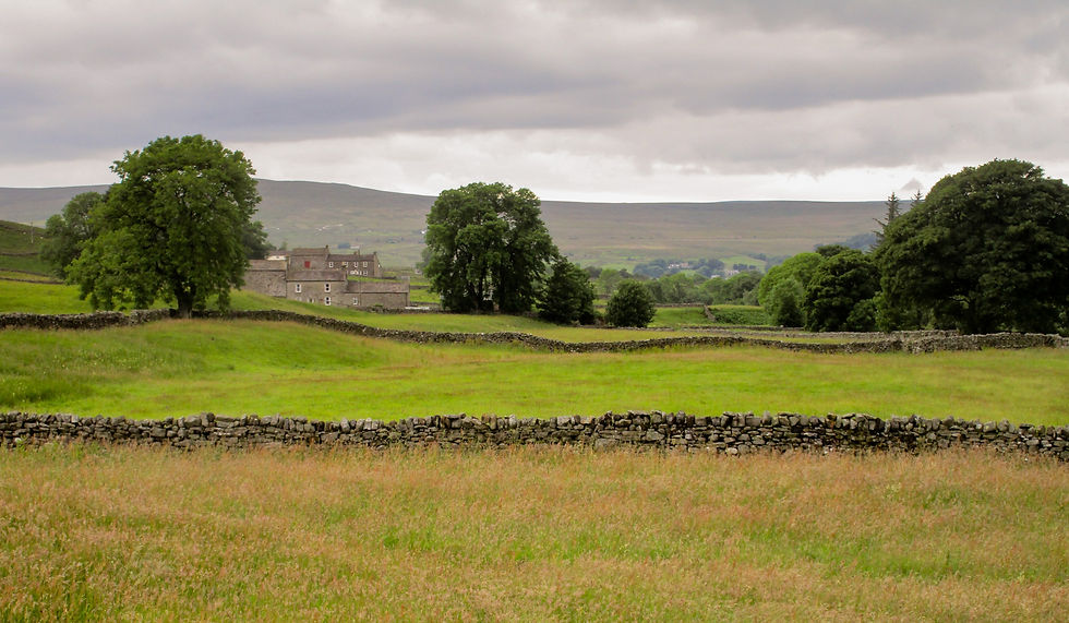
From there it's still five more miles to the end point of Alston. But you're in the company of the river now, and trees, farms, meadows. After so long on the moor it is a feast for the senses.
I plod on, and it hurts. I don’t know whether it’s the new boots, the new insoles, the culmination of a long day with a 3,378ft climb – or simply the number of miles now racking up behind me. Whatever, every step is painful.
The slow, careful gait of one foot in front of the other guides me gently onwards to my eventual stopping point of Alston – the highest and most remote market town in England.
I find a pub, pleased to have company.
Then, even better, my cousin arrives to drive me to his place near Carlisle, where there's a bath, home-cooked food and a bed weighed down by... joy of joys... Tunnock's Caramel Wafers.
Which just about made up for the lonely plod through the Cross Fell wilderness.


Riverside walking along the River South Tyne.

Meadows.

Into Alston.

Alston high street. Lovely old cottages, but the town feels like it has seen better days.


Sam had read my blog post praising the Tunnocks Caramel Wafers at The Langdon Beck Hotel – and had gone six better.
Next: Day 50 – Alston to Greenhead.
Previous: Day 48 – Langdon Beck to Dufton.


Comments